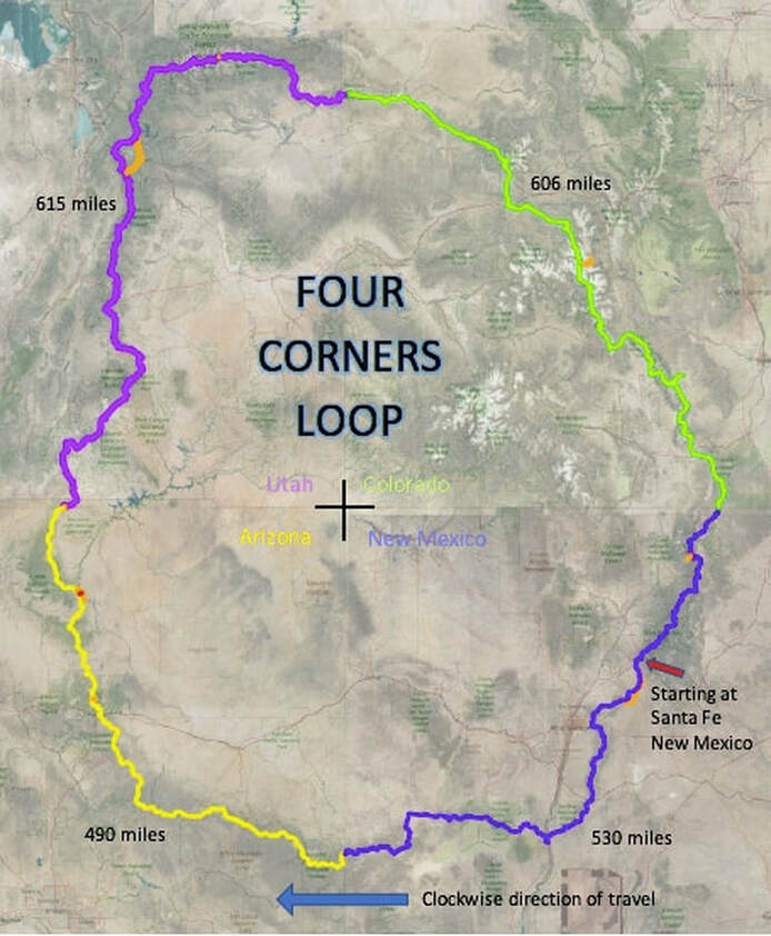
General location of the FCL
Note - I did make some route changes along the way, and this map below is not 100% accurate. Lots of data and labels were removed so it would zoom quickly for this website.
Due to route changes while hiking, avoid private land and hike in more scenic areas. To plan a hike, go to the "Latest CalTopo Link" below. The link had a lot of data and often took a while to load.
The link below is "Map with data." This data will show you the planning data and data I recorded while hiking on the FCL. The CalTopo file is large and complex and can be somewhat slow to use. Over time, I will work on improving this file. If anyone hikes the FCL, I would appreciate any input to improve the map. You could find an improved, more scenic route!
Suppose you zoom in and out of a map and see the data such as water supplies (not all of these have water; many are dry), resupply towns, labels I made, or route changes made. In that case, If you are familiar with CalTopo, you can change layers for your viewing experience. Click on the "Map with data" button below, and it will link you to a read-only map you can configure for your viewing experience.
CAUTION / WARNING / NOTICE / DISCLAIMER:
This is the map I used, and my route changes are recorded to the best of my knowledge. This map is missing a lot of detailed planning information, which made my trip successful. This is not a modern planning tool that you can follow blindly as all the various paid apps hikers use on the AT, PCT, and CDT. My map planning is somewhat old school and requires knowledge of route finding. This map shows the primary route I used in 2021.
Yes, I have drawn lines and data on this file that are on top of private land, and I learned a lot about what is out there on my trial hike. I learned about pitfalls along the way; often, when I encountered the back side of a sign and peered over the fence, I realized I was in a place where someone did not want me. Kevin Koski and this website do not authorize you to cross private land. The trail development section of this website may give some ideas of how to avoid private property, or maybe it will allow local people to embrace the trail and create an easement system for their area. In summation, I did run into areas of private land along the way that I was unaware of, and yes, I did find myself on the back side of some property lines that I was unaware of. So technically, at this point, it is impossible to follow 100% of the line on the map provided, a line I dreamed up when we were running into a roadblock.
If you hike the FCL, find road walks around private land as necessary. Nothing on this website permits anyone to follow my route where a line crosses private land. There are many areas, especially in New Mexico and northwestern Colorado, where road walks are needed to get around private land. These maps show the eventual future state of what I consider a preferred route.
I am currently having issues with the link above. I am working on this as of 1-30-23. It comes up sometimes, and other times, it fails. I have not figured it out. I use this recreational map on my SarTopo/CalTopo account because I also participate in Olympic Mountain Rescue. You might get an error that says Pro Account Required, Trial quota exceeded. There is a ton of data, and I used layers only available to paid accounts. As a fix, the downloadable links might work better on your CalTopo account or another mapping program of choice. Sorry for the glitches, but I am a product of the 1970s, and this is my first website.
|
WARNING:
This is a planning tool that shows my route and not a guide. I have put years of work into these files; these are only for advanced hikers and people who are good route finders. This file may have inaccuracies, and it often crosses land where there are no actual trails. It may show crossing private land, which the file does not authorize you to cross. The water locations may be inaccurate and dry. The Four Corners Loop is not an easy endeavor, and this should not be someone's first long-distance hike due to many cross-country sections, lack of water, lack of actually built trails, and private land issues. This map could get you lost, injured, or even killed. I am not claiming its accuracy; it is just an electronic line on a map with some embedded data. If you follow this route, it will take a lot of planning to avoid the private land I ran into. This is not a simple hike, and my map does not simplify it. Use at your own risk. This trail is not for people who hate to carry water. I never carried less than 5 liters; at one point, I carried 14.5 liters of water. I also had a 54-mile dry section, a 47-mile dry section, and many 30-mile dry sections. |
Vertical Divider
Map symbols used on the latest CalTopo link above are:
Blue Dots - These are water locations I believed to be water when looking at satellite images. Many of these were dry, and many I did not investigate because I carried plenty of water. Red Dots - These are basic GPS waypoints I took along the way. I generally recorded GPS points when I chose not to follow my original planned line because the scenery was better or I had a private property issue. I have generally aligned the lines with my red dots. So, the file here is basically what I walked in 2021. Some red dots also show resupply towns I use or propose to use. Tent Symbols - These are the places I camped for the night. I generally like to dry camp, so these are often far from any water. Question Marks - There are very few of these, but I used these to tell me which arroyo or canyon to go up. They were a decision point marker. Paper Maps - I used Caltopo to format this map file into PDF files so I could color laser print the route on 11x17" Write in the Rain water resistant paper. |
I am assuming you have read all the warnings on this website. When thoroughly read, you can download the full backup ".json," the ".gpx (Routes) or (Tracks), and Google Earth KML" file if you want to use it as a starter for planning your adventure. These files were last updated on 12/17/2023
Latest files as of December 2023
| ||||||||
The picture below is a general overview of the Four Corners Loop; it now has lines where I did not walk.
In March 2021, I started my hike of the FCL; below was my projected itinerary with arrival dates, and while hiking, I added my actual arrival dates. As you can see, I was basically on schedule.
SantaFe, NM. 3/26/21 (Started hiking)
Tijeras, NM. 3/31/21 (arrived 4/1)
Socorro, NM. 4/8/21 (arrived 4/7)
Pie Town, NM. 4/15/21 (arrived 4/14)
Alpine, AZ. 4/23/21 (arrived 4/20)
Pinetop, AZ. 4/29/21 (arrived 4/26)
Forest Lake, AZ. 5/4/21 (arrived 5/1)
Flagstaff, AZ. 5/13/21 (arrived 5/10)
Grand Canyon, AZ. 5/19/21 (arrived 5/15)
{13 days off trail to visit my mom as she passed and I skipped 120 miles of trail and restarted hiking at Wire Pass UT.}
Kanab, UT. 5/26/21 (arrived by plane 5/28)
(Kanab was my Jacob Lake location but I need to hitch to Kanab for a resupply)
Henrieville, UT. 6/2/21 (arrived 6/2 Cannonville)
Escalante, UT. 6/4/21 (arrived 6/5)
Bicknell, UT. 6/9/21 (arrived 6/11)
(Bicknell is my Capital Reef NP location but I need to hitch to Bicknell for a resupply)
Ephraim, UT. 6/17/21 (arrived 6/19)
Spanish Fork, UT. 6/22/21 (arrived 6/25)
Kamas, UT. 6/27/21 (arrived 6/29)
Vernal, UT. 7/7/21 (arrived 7/9)
Maybel, CO 7/14/21 (arrived 7/15)
Meeker, CO 7/18/21 (arrived 7/18)
Glenwood Springs, CO 7/24/21 (arrived 7/23)
Meredith, CO 7/29/21 (arrived 7/28)
+ Buena Vista, CO (arrived 8/1)
Salida, CO 8/5/21 (arrived 8/6)
{visited Westminster, CO for 7 days, my mom’s funeral}
+ Salida, CO (arrived 8/14 again)
Westcliffe, CO 8/14/21 (arrived 8/20)
Fort Garland, CO. 8/20/21 (arrived 8/24)
+ San Luis, CO (arrived 8/25)
+ Red River, NM (arrived 8/28)
Angle Fire, NM. 8/29/21 (arrived 8/31)
Santa Fe, NM. 9/8/2021 (arrived 9/8) DONE! Wow, I actually finished on my planned finishing date!
