About the Route
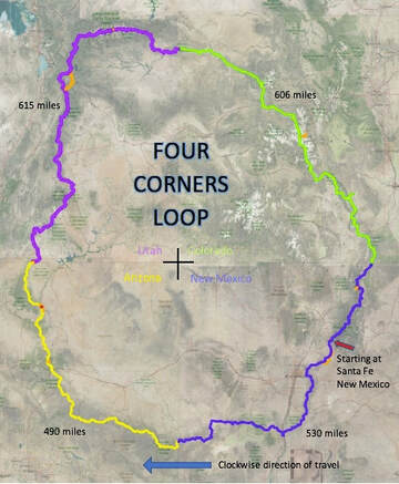
The Four Corners Loop is a collection of routes/trails, lightly traveled jeep roads that can be connected from a path in the shape of a large circle. The center of the trail circle is the actual four-corner region made by the border intersections of New Mexico, Arizona, Utah, and Colorado. The circular-shaped route/trail is approximately 2,352 miles long.
This trail is the idea of Kevin Koski, known as "The Animal" on the CDT and PCT. Kevin received this trail name from Garlic Man while hiking the Continental Divide Trail in 2004 because he speeds up on loose rock and steep snow. Kevin continued to use this name during his 2014 Pacific Crest Trail through-hike and used it while hiking the Four Corners Loop.
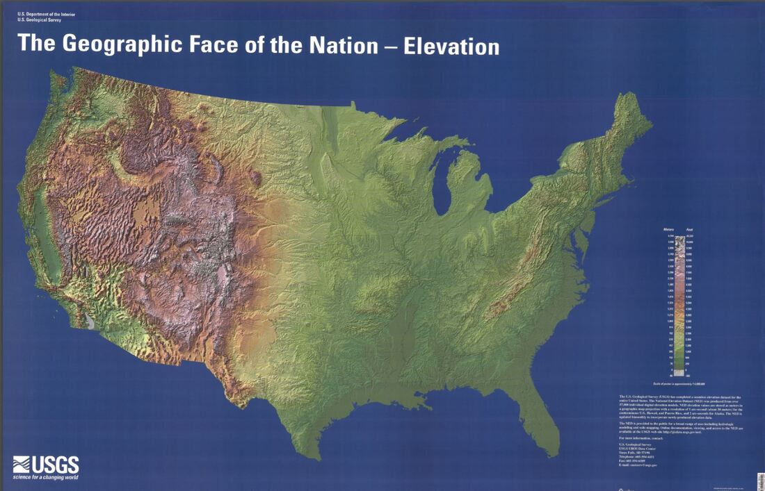
The inspiration for this trail came from the United States Geologic Society map titled "Geographic Face of the Nation - Elevation." When looking at the elevation map, you can see a general circle of mountain ranges and high ridges that form a large diameter circle around the four corners. After this circle of mountains appeared to me, I thought it must be hiked, and this needs to be a new National Scenic Trail.
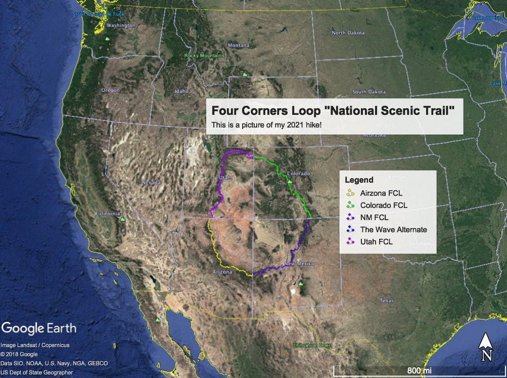
I volunteer with Olympic Mountain Rescue and have access to a mapping program called SARTopo. Since 2018, I have been using SARTopo to explore and create my route virtually. Now that the route has been followed with my own two feet, it shall forever be known as the Four Corners Loop.
2021 is the first known hike of this route but not the last. My ultimate goal is to have this route be hiked by others while allowing it to shift as necessary to make an excellent hiking experience while keeping the general loop shape. New and better paths that others who follow will enable FCL to morph into the nation's first large-diameter hiking circle.
Ultimately, I would love for Congress to vote and add the Four Corners Loop as a National Scenic Trail under the National Trails Act 1968.
This trail is the idea of Kevin Koski, known as "The Animal" on the CDT and PCT. Kevin received this trail name from Garlic Man while hiking the Continental Divide Trail in 2004 because he speeds up on loose rock and steep snow. Kevin continued to use this name during his 2014 Pacific Crest Trail through-hike and used it while hiking the Four Corners Loop.
The inspiration for this trail came from the United States Geologic Society map titled "Geographic Face of the Nation - Elevation." When looking at the elevation map, you can see a general circle of mountain ranges and high ridges that form a large diameter circle around the four corners. After this circle of mountains appeared to me, I thought it must be hiked, and this needs to be a new National Scenic Trail.
I volunteer with Olympic Mountain Rescue and have access to a mapping program called SARTopo. Since 2018, I have been using SARTopo to explore and create my route virtually. Now that the route has been followed with my own two feet, it shall forever be known as the Four Corners Loop.
2021 is the first known hike of this route but not the last. My ultimate goal is to have this route be hiked by others while allowing it to shift as necessary to make an excellent hiking experience while keeping the general loop shape. New and better paths that others who follow will enable FCL to morph into the nation's first large-diameter hiking circle.
Ultimately, I would love for Congress to vote and add the Four Corners Loop as a National Scenic Trail under the National Trails Act 1968.
|
|
Thank you for taking the time to read about the route of the Four Corners Loop.
CAUTION / WARNING / NOTICE / DISCLAIMER:
This trail idea has now been hiked but is not an official trail by any governmental organization; it is my invention, and I make no claims that it will work for others. The route was dreamed up and researched for three years. It was first through-hiked by Kevin Koski in 2021. I do want this to be a new trail others hike, but I take no responsibility for the accuracy of the route or the water sources, and my map even has several places where travel is required off-trail. I fully expect this route to morph and change as I hike, discover impasses, etc. When finished, I will make route modifications based on my experience. When I finish, I will note what worked and what did not. I will use these notes to refine my maps further. Where this association leads is up to me because, as of 2021, the Four Corners Loop Association is a group of one - Kevin Koski
This trail idea has now been hiked but is not an official trail by any governmental organization; it is my invention, and I make no claims that it will work for others. The route was dreamed up and researched for three years. It was first through-hiked by Kevin Koski in 2021. I do want this to be a new trail others hike, but I take no responsibility for the accuracy of the route or the water sources, and my map even has several places where travel is required off-trail. I fully expect this route to morph and change as I hike, discover impasses, etc. When finished, I will make route modifications based on my experience. When I finish, I will note what worked and what did not. I will use these notes to refine my maps further. Where this association leads is up to me because, as of 2021, the Four Corners Loop Association is a group of one - Kevin Koski
Private Property Disclaimer:
This trail has been hiked, and some of my lines on the map page are drawn over private land because it is the obvious scenic and logical path. I avoided most private land and sometimes found myself on the back side of a property sign in the middle of nowhere, so I apologize. Nothing on this website provides any permission to cross private lands. In many places where you can see my line near private lands, I have routed the path to follow publicly accessible roads. There are places where this is impossible, and either letters need to be written by you, the new hiker, or new routes need to be found. Maybe one day, this idea can take off, and easements can be granted.
This trail has been hiked, and some of my lines on the map page are drawn over private land because it is the obvious scenic and logical path. I avoided most private land and sometimes found myself on the back side of a property sign in the middle of nowhere, so I apologize. Nothing on this website provides any permission to cross private lands. In many places where you can see my line near private lands, I have routed the path to follow publicly accessible roads. There are places where this is impossible, and either letters need to be written by you, the new hiker, or new routes need to be found. Maybe one day, this idea can take off, and easements can be granted.
