Click on each state below to see ideas on what can be done to improve the FCL.
New Mexico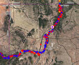
|
Arizona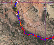
|
Utah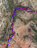
|
Colorado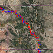
|
When dreaming up the FCL, I used CalTopo and other sources to find a route mainly consisting of footpaths. If these did not exist, I looked for old abandoned jeep trails. I made a considerable effort to stay away from significant dirt roads and tried to avoid paved roads. With this philosophy, my route met most of these criteria, but I could not prevent all paved and major dirt roads. My goal is to have the communities near the route find and build a trail that avoids paved roads and major dirt roads. There are also plenty of areas where easements across private land can be worked through with the land owner.
