 Saturday, July 24
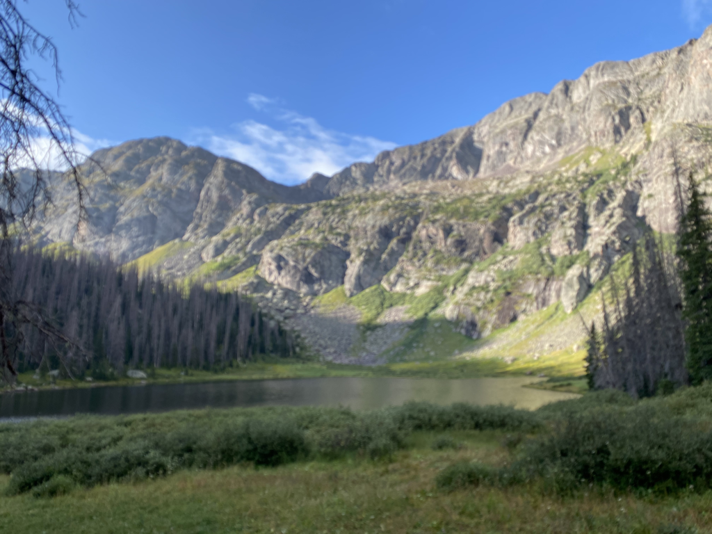
A stroll for 96 miles in flowers. Yes you read this correct I feel like I just spent the last 96 miles walking through a field of flowers. I just completed another section of the Four Corners Loop. This section brought me from Meeker Colorado to Glenwood Springs Colorado through the White River National Forest, and the Flattops Wilderness. As a bonus to the bountiful flowers everywhere came jaw dropping mountain lakes, with green blue water reflecting the mountain scape. Tall white trunks of the aspen trees with leaves fluttering at the slightest breeze, please the soul at lower elevations. The higher elevations were full of lush dark green and blue spruce forests with moss covered branches. I felt as if I was walking through the Pacific Northwest. The forest floor was blooming with fungus which reminded me of perfectly cooked pancakes. The solitude abounds I feel like I was the only person within the Flattops Wilderness. I also had the opportunity to have my first serious thunderstorm and downpour on the Four Corners Loop. Hiking while it is lightning out, feels like a game of Russian roulette. There were trees infrequently spaced about, so I was not the highest thing, but anytime it is lightning your head feels quite high. I love the sound of the thunderous booms that echo back-and-forth making your ears feel alive and grateful to hear the fireworks of nature. I hiked down almost a mile to reach Glenwood Springs along the Colorado river. The town is very silent at this time because I-70 the interstate that travels East/West through Colorado is closed due to mudslides within Glenwood Canyon. Some of these mudslides were created by the thunderstorm I was in the day before. Up in the flattops the thunderstorm was really a gully washer I can just imagine with the mudslides must’ve looked like coming down the canyon walls. I am now relaxing in Glenwood Springs. My body needed a rest so I chose to spend two nights. Today I am going to visit both Hot Springs in town, and get a message so my sore calves and tight hamstrings and quads will be ready for the extreme up and down of the next two weeks. I am not expecting a lot of cellular service for the next 180 miles. I am shooting to reach Monarch Pass by August 7, where my dad will retrieve me from the wilderness so I can attend my mothers funeral in Westminster on August 10. I think about my mom Margaret every day while on this hike, am I am grateful for everything she did for my dad David my sister Kelli, myself, and everybody she touched especially at Holy Trinity Catholic Church in Westminster Colorado. She worked for the church for many years and was a special person to many of the parishioners. She will be missed but the memories of her will bring nothing but joy and smiles as time passes on. Thank you for reading, it is now time for my first Hot Springs reservation. Hot water here I come! The Animal
0 Comments
 Placing feet on the Earth
During planning of the Four Corners Loop, there were two large regions where private land and public land intermingled like meatballs in spaghetti. The first area was where i first set foot on this adventure, between Santa Fe New Mexico and Albuquerque New Mexico. Prior to hiking I wrote letters to three large ranches asking permission to cross their private land. One said no, the other two I never answered back. Since I needed permission from all three and one said no I had to do a slight route change and do about 23 miles of paved road walking, my least desired Earth surface. But this was feasible because the roads were going in the direction that I wanted to go and brought me through the interesting artists colony town of Madrid New Mexico. The other area were private land greatly intermingle‘s with public Bureau of Land Management land (BLM), Colorado state land, Colorado trust land exists between Maybell Colorado and Meeker Colorado. It is your classic checkerboard mishmash of land ownership. In this case the private land holdings were many and small parcels, not huge 50,000 acre ranches, so I didn’t feel it was feasible to write a ton of letters. Instead I incorrectly assumed I could walk along the various dirt roads that connected the public parcels. For this portion of the Four Corners Loop, I placed the route in the area that had the highest land area density of public land, most being controlled by the BLM. It was my thought that the road connecting these parcels placed on the Earth using public funds would be the right away between the public parcels. This was a correct assumption in places, other places this was not a good assumption. Right now walking from Maybell to Meeker is impossible without crossing some private land. A lot of the roads I used created a situation where it was impossible to walk from public parcel to public parcel. Basically I felt like a criminal because there was no water on the 43 mile section (I started out with 14 L), and I did not have extra water to be bushwhacking for a pure public route. Cross country travel is practically impossible in the stiff bushes of this region. Yes they are private lands, but I felt the private lands were blocking access to the public parcels we all own. During the last 42 miles in random places I would see BLM signs stating “entering public land”, “leaving public land” but the later half of the trip what I saw was a whole series of no trespassing signs, even in places where my research showed I was on BLM land. I had no choice but to continue forward not seeing anybody. All the signs were aged in appearance and tattered, the thick impossible vegetation kept me on my course. I was on a road that hasn’t had a vehicle on it in probably 15 years, it might be impossible to even drive unless you were in an ATV. There were landslides present that took out the road (The landslide expose some cool Coal seam layers). The road in places turned to just grass and bushes almost disappearing. There were old broken gates all over the place with old no trespassing signs that haven’t been opened in ages. Every time I encountered a property boundary there was some sort of gate and signage. Even with all this in the middle of nowhere on an abandoned road I would see signs telling me I was entering or leaving public land. Let’s just say this section needs work if this is going to be an official National Scenic Trail, some work with landowners is going to be needed. This is why I’m actually hiking this loop, to learn about these issues and problems so a continuous foot path can exist. If you’re a landowner and you’re reading this and determined I may have crossed your land, I apologize for this, please forgive me. It was definitely a learning experience for me, and I am not going to tell people they have permission to cross your land. When I finish with the trip I will get on the computer and see if I can find a route that is feasible, and some land owners could get letters to asking for permission for other people to hike across their land in the future if hiking the Four Corners Loop. Forgive me because for my safety I needed to continue on my planed route because I did not have enough water to make adjustments on the fly, and there were not any good adjustments to take. Once I got up on the ridge line the bushes kept me moving down the abandoned ridge line road. In my I perfect utopian world I wish the United States was like England. I believe over there people can walk across the land they just have a culture where they open the gate and they close the gate as long as you’re not doing any damage you can walk across the land. Personally I see no harm in walking across land. It would be nice if we had some laws like this in the United States we could walk across the land, staying away from buildings and houses etc., and if walking softly and leaving no trace this traveling practice is considered acceptable. On this route I saw lots of open grand vistas, sagebrush, stiff bushes, many elk, a fox, cows a lot of vast scenic beauty. The section from Maybell to Meeker definitely need some work. I don’t think it’s feasible to do paved road walking in the high heat of this region in Colorado this time of year. It makes sense to get up high and hike the higher hills where it is cooler, but access needs to be achieved. Learning to make a better Four Corners Loop Kevin Koski “The Animal“ 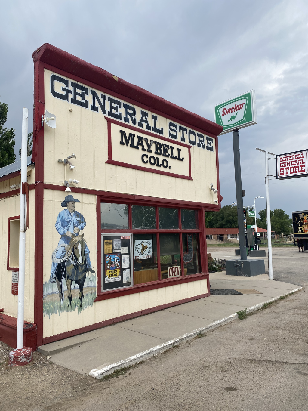 I covered the ground from Vernal Utah to Maybell Colorado in five days. There were some big days in here I did a 23 mile day and a 25.9 mile day. The reason why I was able to do these large mile days was due to the fact I was walking a lot of gravel roads.
This section also had some portions of cross country travel which went pretty well because I found some pretty well-established old trail, elk & cow paths, and chuck wagon roads. Some of the cross country involved walking on hard rock. There was one really sketchy section, getting out of Yampa river back up to the road. I will not tell people to go this way, because it is dangerous. What I did was kind of dumb because climbing up sandstone cliffs when you’re by yourself it’s just not a good idea. Lesson learned no more dumb sketchy sandstone climbing for me, especially when you have a pack laden with 9 L of water. Getting down to the Yampa River was a total bushwhack but it was necessary to get water. The park noticed I was promoting this trail as something other should do, and they really requested that I strictly caution people that walking through the park is not a good idea. I felt like they were very reluctant to give me a permit. I was even pulled me over with flashing lights on the side of the road by the park police to do preventative SAR measures with me. The permit they gave me was through 18 July to transverse the park. I told them it would take me four nights five days to get through the park, turns out it took me three nights four days to get through the park. Three days shorter than the permit the allowed for. This is another classic sign why my trail name fits me so well “The Animal.” I did all this in very high heat, generally I took a siesta during the mid day. I was really impressed with the day I took a four hour break in the middle and still manage to walk 25.9 miles. In this section I was able to get about 30 miles of walking for the amount of water I was caring. I’m going to up the water carrying capacity for the next section, instead of caring 9 L going to carry 11 L. I think the water availability in the next section is going to be extremely limited. This should allow me to walk about 45 to 50 miles before I need to fill up again. If I see anybody driving along the road and they offer me water or I need water, I will not feel shy about asking them. I felt like I had Dinosaur National Monument to myself, nobody was there. I walked the entire Yampa road and only three cars came past. This is a very in frequently visited national monument. So if you want to go somewhere where you have the place yourself consider going to a Dinosaur National Monument. You’re visiting this monument because of the sandstone canyons and the dinosaur bones. I saw both, enjoyed some beautiful sunsets, and became very acquainted with a very long lonely dirt road 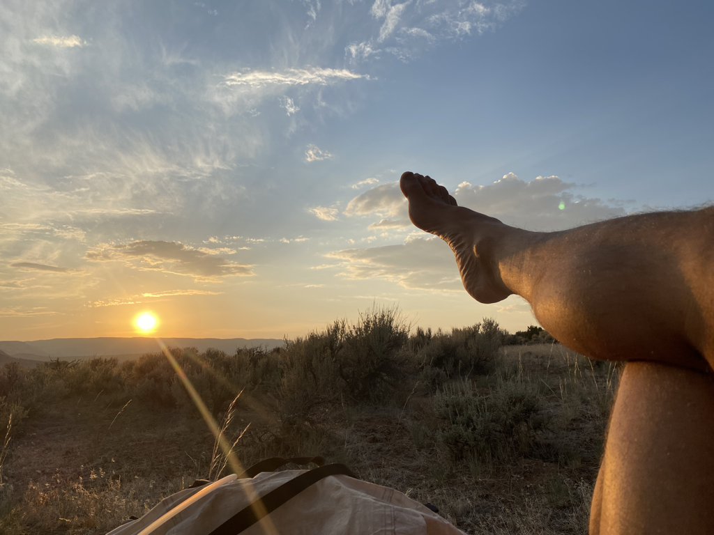 Wednesday, July 14
Nurturing happiness in my soul In Park city Utah I was asked “what have I learned”. The question was asked in an art gallery, and I can tell she was looking for a response containing depth of thought. I was not prepared for such a question especially since it was asked with so much empathy by her and interest expressed for the answer. Simple facts were not being sought, facts like the Uintas are the longest East West mountain range in the U.S., or a pair of tennis shoes lasts 500 miles depending on soil type. Her request necessitates a personal response, something more, something deeper. I didn’t have a good quick answer for her at the time. What did I learn about myself? Struggling to give the lady a good short response, I just said what an unusual question I have not been asked this. I also said it was a good question and my next hiking section I will think about it. I spent the entire 150 miles in the Uintas thinking about this question and it remain unanswered. I came up with some ideas that felt fabricated just to satisfy the question, but these fabrications do not come from the heart. The response is something that needs to rise up from within and cause emotions to flow over my body, a fast impulse feeling, a response that drives my spirit of adventure. Two weeks later after this question was asked, I found myself walking through Dinosaur National Monument. I was struggling with the heat, fly bites, the weight of a pack bearing more water than one should normally carry. I felt myself struggling to walking down the wide untraveled monument road. Then glanced at an unambiguous yellow and white rock about the size of my fist on the side of the road, looking particularly at the colors and texture. I felt an impulse of joyous emotion and happiness quickly build. It tensed up my chest, breathing increased, the feeling welled up to my throat and I left my body in the form of cries of joy exuding out, for all animals in my surrounding to hear. Yes I had a wonderful cry of joy. These were and are my emotions of happiness. I learned that a long walking journey like I am on even though it’s physically hard and difficult brings my soul happiness. When I was a kid I always wanted to have an original idea, something nobody ever thought of before. The Four Corners Loop I feel satisfies the original idea concept. I never felt I could truly have an original idea but I do feel like this idea dreamed up by me results and a happy soul. The day I saw the geographic feature on the elevation profile map of the nation, I merely said wow look at that somebody needs to walk that geographic circle of high mountains, and I decided it would be me. So yes what I’ve learned is I do get soul happiness through doing the tough challenges I give myself. Whether it is hiking for 2,400 miles in a circle, or digging a perfectly straight trench for electrical wires in my backyard for a future electric car. I really appreciate the question I was given an Park City Utah, I will do more thinking about it, but for now I have succeeded and feel will always succeed in nurturing my sole with happiness through my physical hard work in whatever form it takes. Currently it is taking the form of a circle the Four Corners Loop. Thank you for reading, Kevin Koski “The Animal” 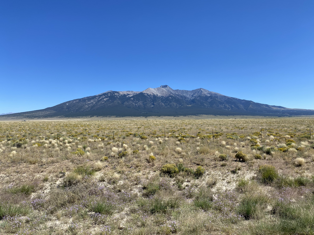 Saturday, July 10
The beauty of the Four Corners Loop continues. I spent the last nine days walking from Kamas Utah to Vernal Utah, covering 153 miles of miraculous mountain terrain. The Uinta Mountain range is the longest East West running mountain range I the United States. I hiked at an elevation generally between 10,500 feet to to 12,500 feet. I did climb the highest mountain in Utah, Kings Peak at 13,528 feet. The views were miraculous you could see up into Wyoming and farther East in range I could see into Colorado. I felt like I could see more than 200 miles to the South. I felt like I was on top of the world, my mind was absorbed in a world class mountain range. Located in one of the highest elevation regions of the United States left me in awe with each step I took. Each day of the nine day crossing, started out sunny and proceeded with cumulus cloud growth contributing to splendid photography opportunities. A few of the days I got showers and a few thunder claps. Generally the weather was just perfect and very comfortable. The flatter glacier carved areas in between the mountain ridges were full of wildflowers and alpine lakes. Walking in each classic “U” shape of each valley you couldn’t help think about the last glacial Ice Age as one walks. I imagined the valleys filled with ice the area would look like a flat ice cap, with nunataks sticking up here and there. I feel the eastern portion of the Unitas were probably more ice covered because the top of the mountains were very rounded versus the western portion the ridges and tops mountains had more sharp pointy peaks. Temperature had its toll on the glaciers they melted away, leaving what we see today. The mountains were composed of sedimentary strata where the sedimentary layers were generally horizontal indicating not a lot of tilt has occurred with the uplift of the mountains. The rocks at the top of Kings Peak give the appearance of a shallow sea where you could see the ripples of water in the deposited sediments on the rock surfaces. This is one of the sections where I encountered the most backpackers I’ve seen so far I think it is because the world class Highline Trail is gaining in popularity, and is such a beautiful place for people to go backpacking. I encountered people from Chicago, Boston, Texas, Seattle and many from Salt Lake City playing in their backyard. I generally saw about 10 people per day the highest day I saw about 25 people near Kings Peak. When I climb Kings Peak I was the first one up there and enjoy the summit to myself. Route finding was pretty easy although there were many areas where it took some good trail sleuthing skills. The trail is very faint in many places, especially in the meadows and having good trail finding skills definitely helps follow the Highline Trail. I hiked down to 5400 feet to the town of Vernal Utah. As a descended I could feel the temperature increase significantly reaching 103° in Vernal. Physically the nine days was very hard and challenging mentally. I mentioned in a previous post that I would write about what I learned on the Four Corners Loop. I am not ready to answer this question but one thing I learned in the section is that I do have physical limits. I feel sometimes I should be able to go farther than I did but I do realize that covering the distance I did in nine days at 45 years young was amazing, and I shouldn’t be so hard on myself for not being able to hike as far as I think I should. Each day when I stopped I was absolutely tanked, stopped because I need to, not because I wanted to. Maybe only hiking 18 miles a day actually allowed me to slow down and enjoy the beauty of the area more. Thank you for reading my post, have a lovely day. Kevin Koski The Animal |
